Shields Tavern Archaeological Report, Block 9 Building 26B Lot 25 Originally entitled: "Marot's Ordinary, Archaeological Briefing"
Colonial Williamsburg Foundation Library
Research Report Series - 1141
Colonial Williamsburg Foundation
Library
Williamsburg, Virginia
1990
MAROT'S ORDINARY
ARCHAEOLOGICAL BRIEFING
MAROT'S ORDINARY
BLOCK 9
Proposed Construction
Proposed construction of an underground kitchen in preparation for converting Marot's Ordinary into a functioning fourth tavern. The kitchen will contain approximately 7,000 square feet of working space and will occupy the shaded area in Figure 1. As plans currently stand, the stable associated with Marot's will serve as a warehouse where restaurant goods are unloaded and an underground tunnel connecting the stable and the kitchen is planned. In order to save the large shade trees bordering the east and west sides of the pleasure garden, the kitchen may be lengthened from north to south and made more narrow from east to west.
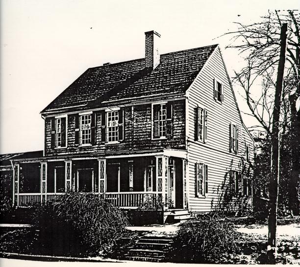
Present Property Appearance
The reconstructed Marot's Ordinary (Figure 2) is a faithful reproduction of what the mid-18th century structure was believed to look like on the basis of archaeological excavations and recollections of its appearance (Charles 1930). Evidence from wills, deeds, and inventories, which were unusually complete and detailed for this property, were also used in the reconstruction of the building.
With the exception of the two necessary houses, all of the outbuildings have been reconstructed to conform to their original foundations. (Anonymous, 1954) A still house and a dairy are located off of the southeast corner of the Ordinary, and a storehouse has been reconstructed at its southwest corner (Figure 3). There is no separate kitchen structure since it is felt by architectural historians that the cooking and related kitchen activities took place in the basement of the ordinary during the 18th century.
The landscape development of the garden is typical of the public house layout in which the entertainment of guests and service activities of the tavern were considered. The Frenchman's Map shows late 18th century fence locations on the property, dividing the yard into several work and pleasure areas (Figure 4).
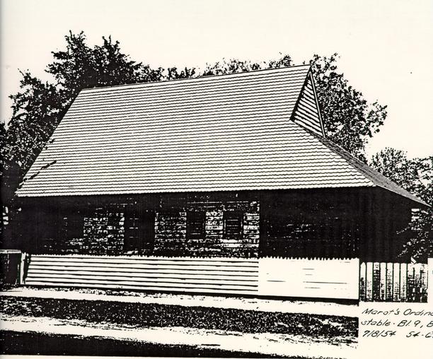
At the extreme southern end of the property, fronting on Francis Street, is a stable and stable yard.
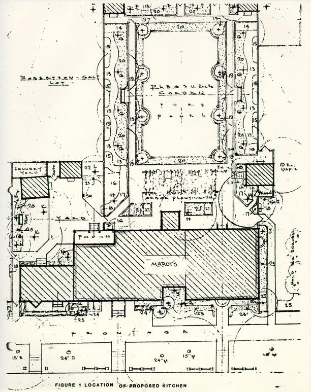 FIGURE
1 LOCATION OF PROPOSED KITCHEN
FIGURE
1 LOCATION OF PROPOSED KITCHEN
 FIGURE
2 MAROT'S ORDINARY
FIGURE
2 MAROT'S ORDINARY
 FIGURE
3 CURRENT PROPERTY PLAN
FIGURE
3 CURRENT PROPERTY PLAN
 FIGURE
4 FRENCHMAN'S MAP SHOWING MAROT PROPERTY
FIGURE
4 FRENCHMAN'S MAP SHOWING MAROT PROPERTY
Background Research
A detailed research report on the Marot Ordinary property was prepared by Mary Goodwin in 1951. The summary presented here was culled from this report.
The present day Marot Tavern reconstruction occupies colonial lot 25 and part of colonial lot 26. During the early 18th century, James Shields owned colonial lots 24 and 25, and in 1708, he sold lot 25 to John Marot. In the indenture between Marot and Shields, the property is described as containing a house. Later in that same year, on May 24, 1708, Marot purchased from William Robertson a piece of land forty feet square out of lot 26 directly to the east. It is probable that Marot enlarged the structure standing on lot 25 soon after buying this property.
Marot applied for and was granted a license to run an ordinary on May 24, 1707. Although there is no record of his owning property in Williamsburg prior to his purchase of lot 24 in 1708, it is possible that he was leasing land, perhaps colonial lot 24, upon which to run an ordinary. Marot renewed his ordinary license each year until his death in 1717. Lot 25 and its associated structures operated as an ordinary by Marot and his heirs from 1708 until the middle of the 18th century, with every indication that the establishment was well-furnished and frequented. William Byrd's diary contains frequent references to his visits to Marot's during 1710 and 1711.
When Marot died in November 1717, Francis Sharpe was accused of his murder. Further details for this incident have not been located. His property was willed to his wife and three daughters and the inventory of Marot's estate prepared at his death showed furnishing for a large establishment. The ordinary's furnishings included 24 beds, 19 tables, more than 50 chairs, and a large supply of liquor. This inventory also mentioned other features on the property, such as the Milk house, the Iron-work in the Kitchen Chimney, and the Kitchen Shed.
After Marot's death, his widow married Timothy Sullivant, and continued the ordinary at Marot's. Timothy Sullivant died around 1730, and Anne Sullivant operated the business until she "retir'd to the Country" sometime prior to August 25, 1738. A notice in the Virginia Gazette for August 25, 1738 shows that John Taylor was continuing the same sort of establishment at Marot's. After Anne Sullivant died in 1742, apparently the estate was divided between her and Marot's three daughters, for, by 1745, James Shields (husband of Anne Ingles Marot) was operating an ordinary on the property. He continued on the lot until his 7 death in 1750. In September 1751, the property was described as "a large house near the Capitol" then vacant, "known by the name of the English Coffee House". Anne Shields inherited the property, and an inventory of Shield's estate lists the contents of the ordinary on a room-by-room basis.
Anne Shields remarried in July of 1751, to Henry Wetherburn. After her remarriage, Shield's property reverted to the Shields' son, James, who was a minor at the time. Wetherburn advertised the ordinary for rent in August of 1751, and it was leased the following month to Daniel Fisher, a tea, coffee and wine merchant from London. Fisher opened a tavern there that same month, but apparently had little success with his business. Besides operating a tavern, he also ran a store there, selling coffee, tea, and wine. Fisher was still occupying the property in April of 1754, when the east end of the house was damaged by fire. Fisher left for Philadelphia in 1755 and records are not clear about whether he stayed there or ever returned to Williamsburg. Information about the property from 1755 to 1770 is scarce, although it is known that James Shields III owned it at this time. It is probable that the house was leased during this period. By August of 1770, James Shields had sold the property to William Goodson, merchant. It was during that month that Goodson indentured part of the property to John Draper, Farrier and Blacksmith. Apparently Draper was leasing a tenement section on the western end of the house, composed of "two rooms a Kitchen and a Shed on the Ground Floor and two Rooms above Stairs"; with "a Blacksmiths Shop behind the same" and "one of the Cellars under the Dwelling House" and half of the garden and part of the stable.
In 1772, Goodson leased the eastern end of the house to Dr. John de Sequeyra, encompassing three rooms at the east end of the house, with the cellar under them. These rooms adjoined a small shop occupied by Thomas Craig, and the rooms and passages above them eastward, with a small adjoining yard and all house kitchens, and shops, except Craig's shop, and half the garden and use of the well. Whether there was any of the property left for Goodson's use is not known. Goodson died in 1781, leaving the property to his wife. She died later that year, and her executors continued to rent the eastern part of the property on Duke of Gloucester Street to Dr. de Sequeyra for a number of years, as he was still there in 1790. In 1799, William Goodson, son of William Goodson offered the property on DOG street for sale. It was not sold immediately, for in 1801, taxes were still being levied on Mary Goodson's estate for the property.
Information on 19th century owners is scarce, but between 1801 and 1806, the property passed to Peter Powell. He owned the property until 1828, and records from 1829 charge the property to Christiana Powell through the will of Peter Powell. In 1850, it passed from Christiana Powell's estate to Peter T. Powell.
8In 1852, the property passed to William W. Ware, who owned it until 1855, when it was charged to William Ware's estate. By 1860, the property belonged to William Blassingham, and during Blassingham's ownership, in 1858, the building on the property was destroyed by fire.
After the fire, a dwelling house, and two shops, used by Thomas Moss for carriage making, were built on the property. A resident, recalling the town in 1861, stated the house built there (known as the Roberts House) had the appearance of having just been built (Figure 5) and to the left of the house in what was the Robert's garden, was a small story and a half frame cottage.
The lot passed from the heirs of Thomas Moss through several hands, and in 1878 the property was owned by Thomas Morecock. Morecock later sold the lot to William Taylor. Several other owner changes occurred, and it was conveyed to the King family, who deeded it to the Peninsula Realty Corporation. The realty corporation in turn sold it to Sophia Wynne Roberts in 1924. In 1928, Roberts sold the property to W.A.R. Goodwin, with a contract for a life tenure. Miss Wynne Roberts moved from the house in early 1952, and the house was demolished later than year. After archaeological investigations were conducted on the property, Marot's Ordinary and outbuildings were reconstructed and completed by June of 1954. The ordinary currently serves as a two family residence for Colonial Williamsburg employees.
 FIGURE
5 ROBERTS HOUSE
FIGURE
5 ROBERTS HOUSE
Prior Archaeological Investigations
Archaeological work was proposed in early June of 1951 (Kendrew 1951), and by the end of July, it was reported that 18th century foundations had been uncovered on the property (Minutes 7-30-51). This archaeological investigation was conducted while the life tenant, M. Wynne-Roberts, was still in residence on the property. Work was confined to the western portion of the property, but it was evident from these excavations that more foundations were existent under the foundation of the Robert's House. The drawing included with the research report of the archaeological evidence uncovered up to November 1951 show the foundations of the western end of Marot's Ordinary. Although no report for this work has been located, some photographs of this excavation exist and the work is documented in the records at the Archives Department.
Mary Goodwin, in her November 1951 Research Report on Marot's Ordinary, stated: "Although some archaeological work has been done on the western portion of the property, a complete investigation of the site cannot be made until the Robert's House is removed". Miss Wynne-Roberts moved from the house at the beginning of 1952, and the house and its associated outbuilding had been removed by February 11, 1952 (Minutes, 2-11-52). The brick foundation walls of the Robert's House were removed to facilitate archaeological investigations and reused in garden walks elsewhere throughout the historic area (Campioli, 1952a).
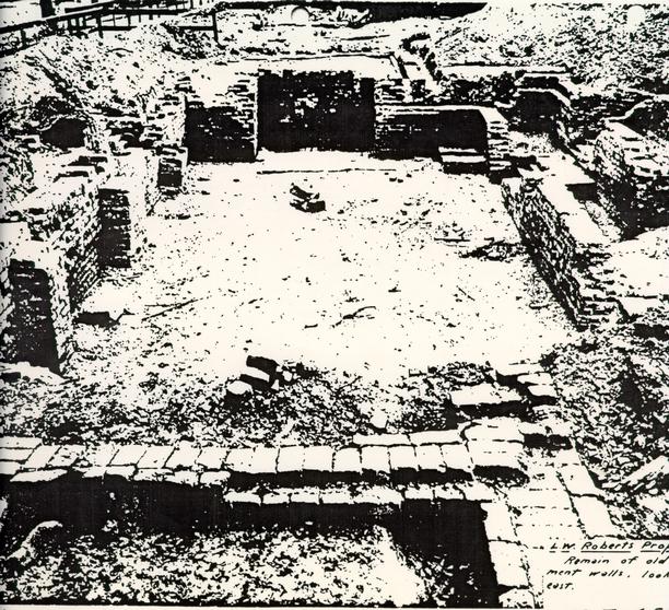
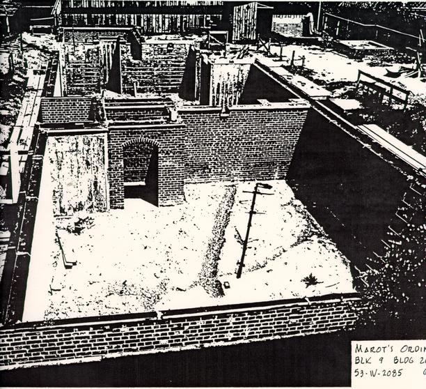
Additional archaeological investigations were begun almost immediately, in March of 1952, with James knight leading the work. Although no report for this excavation has been located, an archaeological laboratory report documenting the artifacts from the excavation was completed in 1955 (Chambers 1955). Photographs and maps documenting the excavation show that in some areas, the fill inside the main house foundation was taken down approximately three feet below grade (Figure 6). In other areas the foundation walls were only exposed, with the interior fill appearing to remain intact (#52-T-2724, #52-T-2725). From documentation, and photographs it is apparent that the main house contained cellars and these were archaeologically examined in 1952 (#52-T-509, #52-T-650).
The entire yard south of the present day Marot's Ordinary, represented by Block 9, Archaeological Area L, was cross-trenched by James Knight (Figure 7). The evidence of this cross-trenching can be seen in archaeological photographs from 1952.
The Archaeological Key Map (Perry, Shaw and Hepburn
1932) shows that the area occupied by the Marot Stable was excavated as
archaeological area G. No report for this area has been
 FIGURE
6 1952 PHOTOGRAPH SHOWING FOUNDATION OF MAROT'S ORDINARY
12
Figure 7. Archaeological Areas Examined by James
Knight.
13
located, and no photographs have been found. No
structural foundations were apparent on the map. It is unlikely that there were
any located through excavation, since all foundations, no matter how small, were
placed on the Archaeological Key Map. It is most likely that cross-trenching was
the method used to explore the property.
FIGURE
6 1952 PHOTOGRAPH SHOWING FOUNDATION OF MAROT'S ORDINARY
12
Figure 7. Archaeological Areas Examined by James
Knight.
13
located, and no photographs have been found. No
structural foundations were apparent on the map. It is unlikely that there were
any located through excavation, since all foundations, no matter how small, were
placed on the Archaeological Key Map. It is most likely that cross-trenching was
the method used to explore the property.
The Robert's House was removed from the property in 1952 and the current day Marot's Ordinary constructed on the basis of archaeological evidence located during 1951 and 1952. Judging from the amount of archaeological remains evident under the Robert's House, however, impart by this 19th century building on any remains there had probably been minimal. This is most likely also the case for the small rectangular one story structure seen on the 1921 Sanborn Map off of the southwest corner of the Robert's House.
Summary of Features Revealed Through Archaeological Investigations
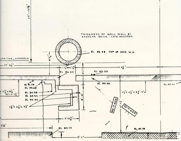
Well
The well is documented on the archaeological map as dating to the first period of construction on the property. This would have placed the well off of the southeast corner of the original structure on the property. No information on the map suggested whether the well was excavated or its depth, but does seem to indicate that a modern well head had been constructed over the well. This could indicate that the well was in use up to the time of the property restoration. None of the photographs taken at the time of excavation show the well. It has been reconstructed in the current property scheme.
Stillhouse
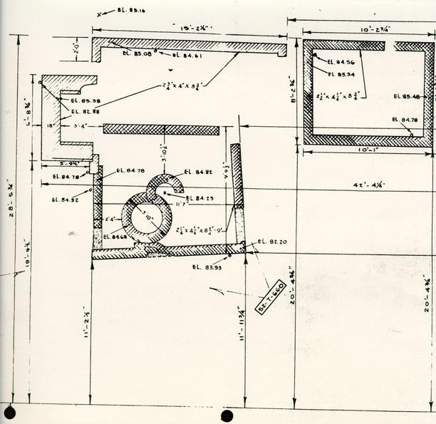
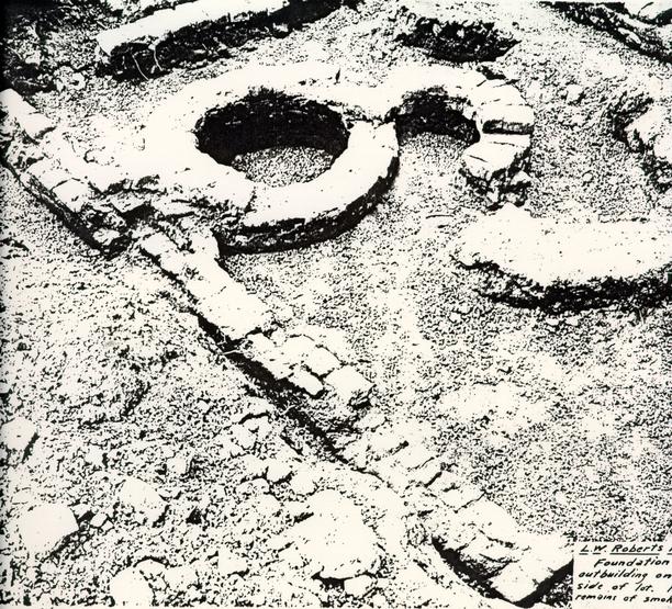
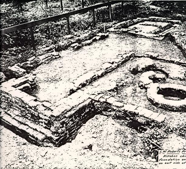
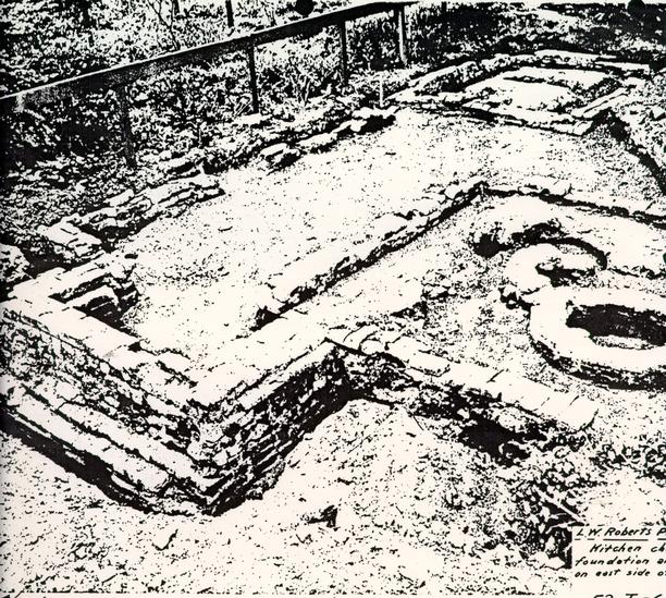
In the inventory of Marot's possessions prepared at his death, two stills were listed as being located on his property. Two sets of brick foundations were located off the southeast corner of the Ordinary. Archaeological photographs from 1952 are labeled as a kitchen chimney foundation with the remains of an outbuilding thought to be a smokehouse seen to the west. The smaller, northernmost foundation, measuring 9'9½" NS x 11'7" EW, was dated to the first period of construction on the property. This structure, containing two circular brick foundations, was later interpreted as a stillhouse. The larger foundation, cutting the stillhouse along the eastern wall and containing a hearth, was dated to the third period of construction. This building will be discussed in the next paragraph. As estimated from examination of the photo record of the excavation, both foundations were located less than six 14 inches below the ground surface. Trenching took: place around the interior and exterior of the foundation walls, and photographs show that some of the interior fill of the stillhouse remained intact. Reconstruction of the stillhouse has taken place, however, examination of the structure shows that the two circular brick foundations have either been removed or reburied.
Outbuilding
Cutting the eastern wall of the stillhouse was a later brick foundation represented by the length of one east-west wall, and portions of both north-south walls. This foundation is labeled as from the third period of construction on the property and measured 15' 2½" EW. The north-south measurements could not be determined because there were no traces of the brick foundations in these areas. The eastern wall of this outbuilding cut the stillhouse and contained a 6'8¾" wide hearth. The function of this probable 19th century outbuilding is unknown. The presence of a hearth would seem to suggest a kitchen, but the small size of the hearth and the presence of the kitchen in the cellar at Marot's make this unlikely. This structure may have been connected with the 19th century carriage operation on the property.
Dairy
Excavations in 1952 located a small rectangular brick foundation (8'3" NS x 10' 1" EW) just west of the stillhouse, and currently reconstructed as a dairy. Archaeological photographs show trenching around the interior and exterior of the foundation walls to a distance of approximately one foot. These trenches also appear to be taken down approximately 8" to 10" below the ground surface. The fill generated from trenching to expose the foundation walls was piled in the interior of the dairy (#53-T-71). Another photograph of the dairy foundations shows the interior fill as largely intact, although an irregularly shaped area, approximately 2' by 3' by 1' deep had been removed from the center of the interior fill (#52-T-656). This hole had the appearance of a shrub or small tree removal hole.
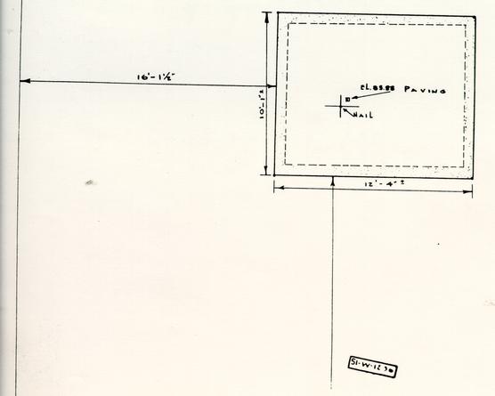
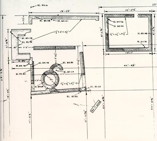
Storehouse
Off the southwest corner of Marot's Ordinary, excavations revealed what appeared from the archaeological map to be traces of a robbed brick foundation. Measuring 10' 1" NS by 12' 4" EW, the outbuilding's interior was paved with brick. This has been currently reconstructed as a storehouse.
Unknown Structure
Located 19' directly south of the central portion of Marot's Ordinary was what appeared on the archaeological map to represent a robbed brick foundation wall. This possible structure measured 20' EW x 8'7" NS, and was comprised of traces (?) of three foundation walls.
15There was no evidence of an easternmost north-south running wall. No photographs were taken during the 1952 excavation to document this feature.
East and West Necessary Houses
The two privies located in the garden to the south of Marot's were not located through archaeological investigations on the property. They were reconstructed in areas where it was believed that privies may have been located. These two structures are built on piers, and the deep hole which would have been associated with functional privies is absent.
Robert's Garage
(Block 9, Building 40) Photographs dating from 1932 of this structure show that it rested on piers, and thus had no substantial foundations. This garage was demolished in 1952 (Minutes, 1952).
There have been several monitoring projects which have taken place around the Marot property in the past several years.
Lamp Post Monitoring Protect
During February of 1984, a lamp post was located just north of Marot's Ordinary (Myzk, 1984). Since this project took place north of the Ordinary, it was not in the area of the underground kitchen project and will not be considered here. Copies of this report are on file at OEC.
C&P Telephone Repair
Archaeological monitoring in response to C&F' telephone repair work was performed in May of 1984. The trench profile indicated that this area had been disturbed by utility maintenance activities (Alexandrowicz 1984). Since this work was also located in an area shown to contain an underground oil tank, the installation of the tank may have caused the disturbance seen during monitoring.
Other Disturbances to the Property
Throughout the 20th century, the usual types of disturbances related to the upkeep of residential property have occurred. For example, several bushes and trees have been relocated or removed, and in 1929, the Williamsburg Restoration proposed to do garden landscaping on the property. The life tenant, however, wanted to reach an agreement with the landscape architect before this work was carried out. Records of this work proposal ceased toward the end of 1929, without its apparently having taken place.
When the ordinary was reconstructed in 1953, the
original foundation walls of Marot's were removed (Figure 8), and samples of the
brickwork: preserved (Campioli 1952b). Grading occurred
 FIGURE
8 CONSTRUCTION OF MAROT'S ORDINARY
17
on the property in connection with the reconstruction
(Hackett 1953), and some of this grading likely took place in the garden area.
FIGURE
8 CONSTRUCTION OF MAROT'S ORDINARY
17
on the property in connection with the reconstruction
(Hackett 1953), and some of this grading likely took place in the garden area.
Archaeological Potential
Documentary sources indicate that during the last quarter of the 18th century, there was a blacksmith's shop behind the western end of the house, and also a garden and a stable on the property. After the 1858 fire which burned the original Marot's Ordinary, the Roberts House and two shops used in carriage making were constructed on the property. With the exception of the Roberts house and possibly one of the carriage shops, none of these other structures or garden remains were located during the 1951 and 1952 excavations.
Since the method used to examine the yard and property of Marot's Ordinary in 1952 was cross-trenching, the likelihood of substantial archaeological remains on the property is good. Archaeological excavations on the Marot property should be able to provide information about the use of the garden and yard behind the Ordinary, allowing for more accurate reconstruction. Evidence of yard use areas, trash disposal patterns, evidence of walkways and the presence of post-in-the-ground structures are the types of information which are likely to remain intact on the property.
The stable (Figure 9) as now reconstructed on Francis Street stands in the location of a structure depicted on the Frenchman's Map. This most likely is the stable which has been documented as standing on the Marot property. Archaeological trenching at this location (Archaeological Area G) turned up no traces of a structure with a brick foundation, however, it is possible that the structure may have been earthfast and required no brick foundations. Photographs taken during the construction of the current stable show very little if any ground disturbance. If a structure did stand at that location, as depicted on the late 18th century map, then excavation in connection with the proposed kitchen will most likely be able to locate evidence of this structure in the form of walkways, trash scatters, and drip lines. If a basement is to be placed under the stable structure, archaeological investigations underneath this structure will also be necessary.
Archaeology in the garden of Marot's Ordinary may also be able to show exact locations for privies contemporaneous with the reconstructed tavern. If the ordinary had outdoor arbor seating, archaeology should be able to locate remains of the posts which would have been used to support the arbor.
 FIGURE
9 MAROT STABLE
FIGURE
9 MAROT STABLE
Archaeology in the south yard of Marot's Ordinary would be important in tracing the changes which have occurred on the property over time. This property, unusually well documented, was known to have served as an ordinary throughout most of the 18th century. Artifact assemblages from this property would provide enormous research potential for comparison with other excavated taverns in the area, such as Wetherburn's. The archaeology of Marot's yard and stable area will provide information for the accurate reconstruction of the ordinary yard.
BIBLIOGRAPHY
- 1984
- Unpublished monitoring report on C & F Telephone Repair. On file at Office of Excavation and Conservation, Colonial Williamsburg Foundation, Williamsburg, VA.
- 1954
- Marot's Ordinary 1707-1858. Public Opening June 27, 1954. Reconstructed to the Period of 1750 by Colonial Williamsburg. Unpublished brochure on file at Colonial Williamsburg Foundation Central Library, Williamsburg, VA.
- 1952a
- Memo to I. L. Jones Jr. dated February 18, 1952. On file in folder for Block: 9, Building 26B, Marot's Ordinary Landscaping 1951-1960. Colonial Williamsburg Archives, Williamsburg, VA.
- 1952b
- Memo to C. E. Hackett dated December 1, 1952. On file in folder for Block 9, Building 26B, Marot's Ordinary 1951-1954 Block and Building File. Colonial Williamsburg Archives, Williamsburg, VA.
- 1955
- Archaeological Laboratory Report of Marot's Ordinary Excavations. Unpublished report on file at Colonial Williamsburg Central Library, Williamsburg, VA.
- 1930
- Recollections of John S. Charles. Typescript on file at CWF Research Center, Colonial Williamsburg Foundation, Williamsburg, VA.
- 1951
- Marot's or The English Coffee House. Unpublished research report on file at Colonial Williamsburg Central Library, Williamsburg, VA.
- 1953
- Memo to M. E. Campioli dated June 9, 1953. On file in folder for Block 9, Building 26B, Marot's Ordinary Landscaping 1951-1960. Colonial Williamsburg Archives. Williamsburg, VA.
- 1951
- Unpublished memo to M. E. Campioli dated June 6, 1951. On file in folder for Block 9, Building 26, L. W. Roberts House, 1951-1952 Block and Building File. Colonial Williamsburg Archives, Williamsburg, VA. 22
- 1951
- Excerpts from minutes of Architecture, Construction and Maintenance Division Building meeting of July 30, 1951. On file in Folder for Block 9, Building 26, Roberts House, 1951-1952 Block and Building File. Colonial Williamsburg Archives, Williamsburg, VA.
- 1952
- Excerpts from minutes of Architecture, Construction and Maintenance Division Building meeting of February 11, 1952. On file in folder for Block 9, Building 26, Roberts House 1951-1952 Block and Building File. Colonial Williamsburg Archives, Williamsburg, VA.
- 1984
- Lamp Post Monitoring Project. Marot's Ordinary. February 28, 1984. Unpublished report on file at Office of Excavation and Conservation, Colonial Williamsburg Foundation, Williamsburg, VA.
- 1932
- Archaeological and Research Key Map of Restoration Area, Williamsburg, Virginia. Williamsburg Restoration for Williamsburg Holding Corporation. Copy on file at Office of Excavation and Conservation, Colonial Williamsburg Foundation, Williamsburg, VA.
SUMMARY SHEET-KNOWN ARCHAEOLOGICAL FEATURES
FEATURE: Stillhouse
DESCRIPTION: Rectangular brick foundation located off of the southeast corner of Marot's Ordinary. Measures 9'9½" NS x 11'7" EW and is cut by a later structure containing a hearth at its east end. A circular brick foundation, 3'10" in diameter is located along the northern wall of the outbuilding, and it is overlaid at its southern perimeter by a smaller, brick semi-circle.
LOCATION: The northeast corner of the stillhouse is located 28'6" south of the southeast corner of Marot's Ordinary.
ASSOCIATED ARTIFACTS REPORTED: no specific references to artifacts
REPORTED DEPOSITION OF ARTIFACTS: Warehouse, OEC, Section 7
CURRENT COLLECTION STATUS: unknown
INVESTIGATOR (S): James Knight, 1952
CONDITION: This outbuilding has been reconstructed, which most likely entailed removing the original brickwork. The brick still foundations are no longer visible.
PAST INTERPRETATION AND SIGNIFICANCE: The inventory of Jean Marot's estate showed that he owned two stills. The 1953 archaeological map for the property interprets the later structure with the hearth as a kitchen. and the smaller, northern section as a stillhouse. The stillhouse was labeled as "first period of construction" while the southernmost foundation was labeled as "3rd period of construction".
EXCAVATION TECHNIQUE: Cross-trenching to locate the foundation walls, with subsequent trenching around the interior and exterior of the foundations walls.
ADDITIONAL COMMENTS:
24REFERENCES: Archaeological Survey of Foundations on Marot's
Ordinary, Williamsburg, VA. Block 9, Area L. July 1953. Scale ¼"=1'.
Archaeological Photographs
#52-T-660 #52-T-657
 MAROT'S
STILLHOUSE
MAROT'S
STILLHOUSE
BLK 9 BLDG 26E
53-7-70 1-7-53
 L.W.
Roberts Property
L.W.
Roberts Property
Foundation of early outbuilding on east side of lot. Probably remains of
smokehouse. 52-T-660
 L.W.
Roberts Property
L.W.
Roberts Property
Kitchen chimney foundation and outb[uilding]
on east side of lot. 52-T-657
SUMMARY SHEET-KNOWN ARCHAEOLOGICAL FEATURES
FEATURE: Dairy
DESCRIPTION: Brick foundation uncovered through archaeological excavation. Measured 10'1" EW x 8'2" NS. Foundation walls measured 9" wide.
LOCATION: 37'9" from the south foundation wall of the east wing of Marot's Ordinary. Also located 5' west of the west wall of the stillhouse.
ASSOCIATED ARTIFACTS REPORTED: no specific references to artifacts
REPORTED DEPOSITION OF ARTIFACTS: Warehouse, OEC, Section 7
CURRENT COLLECTION STATUS: unknown
INVESTIGATOR (S): James Knight, 1952
CONDITION: Dairy has been reconstructed. This reconstruction most likely necessitated the removal of the 18th century foundation walls. There may be some intact cultural layers remaining inside of the dairy.
PAST INTERPRETATION AND SIGNFICANCE:
EXCAVATION TECHNIQUE Building located through cross-trenching, with subsequent trenching around the interior and exterior of the foundation walls. Trenching was taken to a depth of 8-10" below the ground surface. Photographs taken during excavation show what appears to be a shrub removal hole in the center of the interior fill. This hole measured approximately 2' x 3' x 1' deep.
ADDITIONAL COMMENTS:
REFERENCES: Archaeological Survey of Foundations on Marot's Ordinary, Williamsburg, VA. Map drawn July 1953. Scale 1/4" = 1.0'.
Archaeological Photographs
#52-T-656 #52-T-657

 L.W.
Roberts Property
L.W.
Roberts Property
Part of kitchen and outbuilding foundation located on east side of lot.
52-T-656
 MAROT'S
DAIRY
MAROT'S
DAIRY
BLK 9 BLDG 26F
53-T-71 1-7-53
 L.W.
Roberts Property
L.W.
Roberts Property
Kitchen chimney foundation and out. on east side of lot.
52-T-657
SUMMARY SHEET-KNOWN ARCHAEOLOGICAL FEATURES
FEATURE: Storehouse
DESCRIPTION: The map of the 1952 archaeological excavations suggest a 12'4" EW x 10'1" NS frame structure located off of the southwest corner of Marot's Ordinary. The symbol used on the map for depicting the brickwork is that which was often used when the brick was robbed, having left only traces of the wall's former location. The interior of the structure was described on the map as being paved.
LOCATION: The storehouse was located 19' off of the southwest corner of Marot's Tavern.
ASSOCIATED ARTIFACTS REPORTED: no specific references to artifacts
REPORTED DEPOSITION OF ARTIFACTS: Warehouse, OEC, Section 7
CURRENT COLLECTION STATUS: unknown
INVESTIGATOR (S): James Knight, 1952
CONDITION: Storehouse has been reconstructed on its original location. This reconstruction may have destroyed the colonial brickwork remaining. There were no archaeological photographs of this feature, and the only documentation of its existence is that represented on the archaeological map.
FAST INTERPRETATION & SIGNFICANCE: I could find no explanation as to why the outbuilding was reconstructed as a storehouse. There is mention of a "kitchen shed" in the probate inventory taken at Marot's death in the first quarter of the 16th century. There is no reference to any type of storage building in the records which concern James Shields II or William Goodson.
EXCAVATION TECHNIQUE: Most likely cross-trenching to locate the brickwork. If the floor was paved, as is indicated on the map, then all of this brickwork would have been exposed, although it is doubtful that it would have been removed at the time of excavation.
ADDITIONAL COMMENTS:
REFERENCES: Archaeological Survey of Foundations on Marot's Ordinary, Williamsburg, Virginia. Map Scale ¼"=1.0'.
SUMMARY SHEET-KNOWN ARCHAEOLOGICAL FEATURES
FEATURE: Well
DESCRIPTION: Well has 5'0" outside diameter and a 3'6" inside diameter. Archaeological map states that the thickness of the well wall was 8" composed of regular brick with laid headers.
LOCATION: Located 2'0" south of the south wall and 36'0" east of the southwest corner of the Ordinary.
ASSOCIATED ARTIFACTS REPORTED: none
REPORTED DEPOSITION OF ARTIFACTS: unknown
CURRENT COLLECTION STATUS: unknown
INVESTIGATOR (S): James Knight 1952
CONDITION: This well now stands just south of the Ordinary and may have been reconstructed. There were no photographs taken at the time of archaeological investigation, and the archaeological map labels the well as having a modern well head. It is possible that this well, labeled on the map as dating from the first period of construction on the property, was functional at the time of the archaeological excavation or in the recent past.
PAST INTERPRETATION AND SIGNFICIANCE: Archaeological map labels the well as dating from the "first period of construction".
EXCAVATION TECHNIQUE: Unknown, but if the well was completely underground in 1953, it was most likely located through cross-trenching.
ADDITIONAL COMMENTS:
REFERENCES: Archaeological Survey of Foundations on Marot's Ordinary, Williamsburg, VA. Scale ¼" = 1.0'.
SUMMARY SHEET-KNOWN ARCHAEOLOGICAL FEATURES
FEATURE: Outbuilding
DESCRIPTION Brick foundation of outbuilding measuring 15'2 ½" EW. North-south measurements could not be determined because traces of the complete n-s walls had been destroyed. The northeast corner of this building cut the earlier foundation of the stillhouse. The outbuilding contained a hearth (6' 8 ¾" NS x 3' 9 1.2" EW outside measurements) on its eastern end.
LOCATION: The northernmost foundation of the hearth is located 36'6" from the southeast corner of Marot's Ordinary.
ASSOCIATED ARTIFACTS REPORTED: unknown
REPORTED DEPOSITION OF ARTIFACTS: unknown
CURRENT COLLECTION STATUS: unknown
INVESTIGATOR (S): James Knight 1952
CONDITION: This building has not been reconstructed and it is likely that its foundation walls were removed when the stillhouse was reconstructed in 1953.
FAST INTERPRETATION AND SIGNIFICANCE: Photographs which show this outbuilding at the time of archaeological investigation label it as a kitchen. It is also labeled on the archaeological map as dating from the "third period of construction". It was later determined that the cooking and kitchen activities for the Ordinary took place in the basement of Marot's. Haled on this documentation, combined with the small size of the hearth, this outbuilding most likely was not a kitchen. It is possible that this building may have been one of the two shops built to house a carriage making activity after the 1858 fire on the property.
EXCAVATION TECHNIQUE: Building located through cross-trenching, and foundation walls trenched around on both the interior and the exterior.
ADDITIONAL COMMENTS:
REFERENCES: Archaeological Survey of Foundation on Marot's Ordinary, Williamsburg, Virginia. Scale ¼" = 1.0'.
Archaeological Photographs Negative Numbers
#52-T-660 #52-T-657
 L.W.
Roberts Property
L.W.
Roberts Property
Kitchen chimney foundation and out. on east side of lot
52-T-657
SUMMARY SHEET-KNOWN ARCHAEOLOGICAL FEATURES
FEATURE: Unknown Structure(?)
DESCRIPTION: This feature is seen on the archaeological map for the property as a rectangular structure whose only evidence of existence was the traces of three robbed foundation walls. The westernmost north-south wall measured 8'7" in length. The southernmost east-west running wall measured 20' in length and may have kept extending to the east. The northern east-west running wall, however, appeared to have a definite stopping point and was only 18'5 ¼" long.
LOCATION: The northernmost foundation footprint was located 20'6" south of Marot's Ordinary. The western trace of the structure was located 46' from the western corner of the Ordinary.
ASSOCIATED ARTIFACTS REPORTED: unknown
REPORTED DEPOSITION OF ARTIFACTS: unknown
CURRENT COLLECTION STATUS: unknown
INVESTIGATOR: James Knight, 1952
CONDITION: Although there are no photographs of these structural remains, its depiction on the archaeological map suggests that the only traces found of the building were those left behind by a robbed brick foundation wall. It is unlikely that traces of this structure remain in light of the fact that large machinery was used in the construction of the ordinary, and in view of the current landscape plan. This area is now covered with a brick paved courtyard, which surely necessitated the placement of the brick paving on a sand bed. Any traces of these robbed out walls, if they were the foundation for a shallow brick foundation upon which a frame structure would rest, would surely have been destroyed by even the slightest grading for the construction of the courtyard.
PAST INTERPRETATION AND SIGNIFICANCE: Unknown. This building has not been reconstructed on the Marot property.
EXCAVATION TECHNIQUE: Unknown, but most likely located through cross-trenching.
ADDITIONAL COMMENTS:
REFERENCES:
Archaeological survey of foundations on Marot's Ordinary, Williamsburg, Virginia. Scale ¼" = 1.0'